
How does a weather radar work?
So, you want to know how does a weather radar work?
In this blog post, we’re going to take you through just that!
A weather radar is a device that takes data from the atmosphere and displays it in an image. Meteorologists often use these images to predict future events, such as storms or tornadoes. Radars can also be used for non-meteorological purposes, such as tracking aeroplanes or ships.
Radio Waves
Weather radars work by emitting radio waves into the air and recording how long it takes for them to bounce back after hitting rain droplets, hailstones, birds, insects, planes and other weather elements that may exist in their path of travel.
The most basic form of Weather Radar (Rain Radar) is the type that measures rain as it falls. This is also called “reflectivity” or “Z-R”.
Radar can track a storm’s motion and predict where its centre will be in about half an hour, which gives communities enough time to prepare for any localised floods or power outages anticipated by the weather patterns.
The time between when a wave was sent out and when it returns is then translated into what’s called a reflectivity factor which shows how many particles are present within each volume of space.
This data is then used to create the image displayed on the screen and, depending on what it shows, can be treated as an early warning system for potentially dangerous weather events like tornadoes or hurricanes.
Radars are also able to detect turbulence in the air which helps pilots avoid bumpy landings by giving them advance notice when there may be a problem with the smoothness of their flight.
Various forms of weather radars have been in use for more than 40 years and, though each operates using slightly different components, all rely on the same basic principle to get results.
How does a weather radar work?
Modern weather radars are mostly pulsed-Doppler radars detecting rain droplets and precipitation. Data are analysed to determine the structure and potential for violent weather.
Radar could also be used in models for preparing the weather for example High-Resolution Atmospheric Prediction.
For newspaper and utility companies radar was the basic engine for their prediction strategy.
Meteorologists use radar to keep users updated so they can learn how to prepare for heavy rain and decide when or where to issue warnings.
Utility companies use radar data to monitor conditions and to find out when and how to deal with adverse conditions.
The preparations for an eventual outage.
At Phuket Island Radio we understand weather radar and it is one of the keys to providing reliable forecasts.
Numerical weather predictors
Radar output can even be incorporated into numerical weather predictors to improve analysis and forecasts.
A weather radar is being utilised by the National Weather Service, research departments in Universities and television broadcast weather departments.
Raw images are regularly used, and specialised software can take radar data to make short-term forecasts of future positions and intensities of rain, snow, hail and other weather phenomena.
How radar works
A weather radar is a radio detector that tracks precipitation like hail and rain and detects them from a point in time.
The time it takes to hear the pulse return determines the distance of the rain, and the strength of sound to be felt gives information regarding the type of precipitation. The antenna rotates one time every 20 seconds but as you can read both high altitude and low level (with a rainfall camera in your pocket) a 14-second surge takes effect.
We use radar images from our websites for the most recent four sweeps in a set. This should reduce some of the problems with blocking from hilltops and help show a fuller homage to Phuket.
Why is accurate weather radar data so important?
Radar offers reliable weather forecasts that provide real-time and quick hourly service.
What is a weather radar?
Weather radar sends electromagnetic pulses into the atmosphere to detect precipitation, determine their motion and intensity and identify the precipitation type, such as rain snow or hail. Radar can be an extraordinarily vital tool within the toolbox of meteorologists helping reshape lives and property.
Meteorologists can use the information to identify locations with hazardous weather conditions. Radar uses electromagnetic energy to track drops, snowflakes, hail and raindrops. Using the radar the meteorologist will identify dangerous places at certain spots to improve surveillance in these.
What’s on the radar image?
A colour spectrum is used to indicate the intensity of the rainfall with black being heavier rain often indicates hail. One photo is displayed all the way around 60 to 10 minutes this creates a 30-minute loop.
It is important to note, that these are not predictions: they show you where the rains have been so you’re able to tell where the rain will be next. Some radars also display wind speed.
On our website, the time is displayed next to the radar so that if you view a radar at one time or move to other time zones you know you’re looking at the same time.
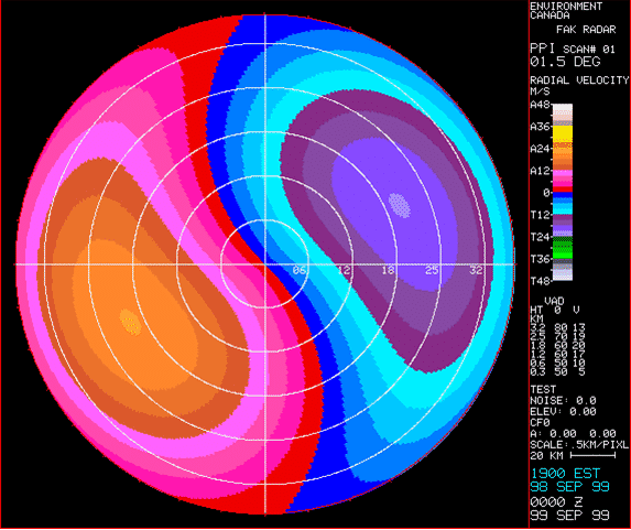
Doppler radars
Doppler radar is a type of radar system that uses the Doppler effect to measure the motion of objects, such as raindrops or snowflakes, in the atmosphere. The Doppler effect refers to the change in frequency or wavelength of waves (such as sound or electromagnetic waves) when there is relative motion between the source of the waves and the observer.
In the context of weather radar, it is used to detect the movement of precipitation particles in the atmosphere.
The weather is constantly changing, so the technologies used to predict it are also changing.
Doppler radars allow meteorologists to track these changes and forecast accordingly.
Radio-based Doppler weather radar systems are rapidly becoming the most accurate form of weather prediction available.
This is because they allow meteorologists to track changes in atmospheric conditions with pinpoint accuracy.
Thus, giving them an unrivalled understanding that was previously unattainable by any other means.
Here’s how the Doppler radar system works
- Emitting and Receiving Signals: The Doppler radar emits a focused beam of electromagnetic waves, usually in the microwave or radio frequency range. These waves travel through the atmosphere and encounter precipitation particles (such as raindrops or snowflakes). Some of the waves bounce off these particles and return to the radar.
- Measuring Frequency Shift: When the radar waves encounter moving precipitation particles, the frequency of the returned signals changes due to the Doppler effect. If the particles are moving away from the radar, the frequency decreases (lower pitch), and if they are moving toward the radar, the frequency increases (higher pitch).
- Data Analysis: The radar system analyzes the frequency shift of the returned signals to calculate the radial velocity of the moving particles. This information helps meteorologists determine the speed and direction of the winds within the storm system.
How accurate are Doppler radars?
The Doppler radar system is an integral part of understanding how the atmosphere works now and in future.
Advantages of Doppler radar for weather forecasting
- Precise Wind Information: Doppler radar provides valuable real-time information about the wind speed and direction in storms and weather systems. This data is crucial for understanding storm behavior, such as the rotation of tornadoes or the development of severe thunderstorms.
- Early Detection of Severe Weather: Doppler radar can detect changes in wind patterns and identify storm structures that may lead to severe weather events. It allows meteorologists to issue timely warnings for events like tornadoes, hailstorms, and heavy rainfall, providing more time for people to take necessary precautions.
- Quantitative Precipitation Estimation: Doppler radar helps in estimating the intensity and volume of precipitation in a specific area. By analyzing the radar echoes, meteorologists can assess rainfall rates and potential flooding risks, aiding in flood monitoring and management.
In summary, Doppler radar is a powerful tool in weather forecasting as it provides crucial information about wind patterns, severe weather detection, and quantitative precipitation estimation. Its ability to track the motion of precipitation particles allows meteorologists to gain a better understanding of weather systems and enhance the accuracy of weather forecasts and warnings.
What the weather radars can’t detect.
The curvature of the planet means the radar beams’ ultimate range is 5 to 200 kilometres. Within 200 km its radar could be able to detect rainfall falling in the atmosphere.
Low-level drizzle is very hard for radar because the droplets are so tiny and close to the ground. Normally echoes are not displayed near the radar because radar doesn’t have any of its echoes in direct line with it.
Radars can detect “Virga,” rain that drops but evaporates before a source gets close to a spot. So sometimes radar sometimes comes into view when this happens.
What do weather radar colours mean?
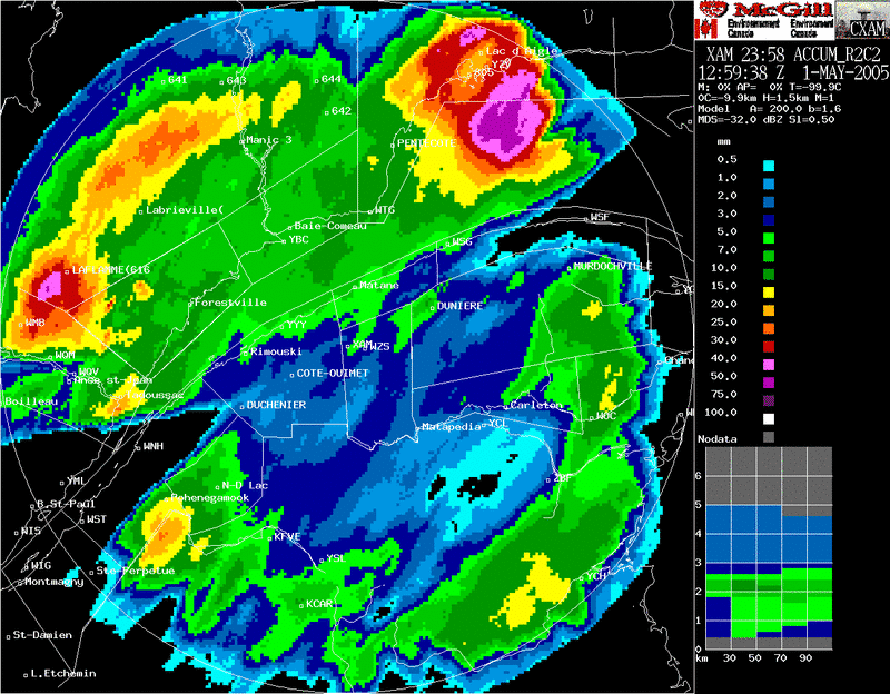
Weather radar transmits the information to a computing chip that produces the vibrant green, yellow and red colours seen daily by forecasters.
Typically heavier rain shows warmer colours.
Using the Max Broadcast product users can configure their own colour tables for the last updated weather forecasts.
Red indicates rainstorms or hail; green indicates light rain: white indicates.
Show the key developments in weather radar technology.
The weather technologies we use and interact with on a daily basis are evolving at an astonishing rate.
Over the past few years, advancements in data analysis have propelled our understanding of weather patterns into uncharted territory. The next big step will be connecting these emerging technologies.
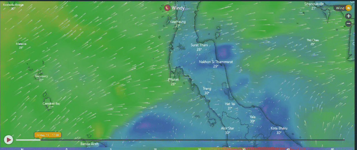
Now it is time to take all that learning and read a live weather radar for Phuket.
Above is the Phuket Radar showing wind direction and wind strength.